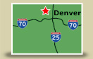
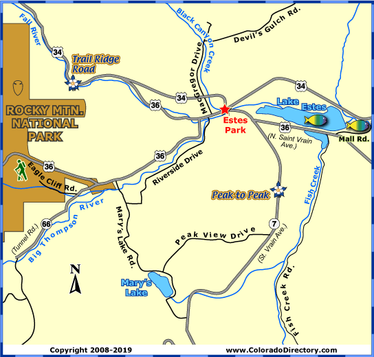
Colorado Maps - Estes Park Area Map - The Colorado Vacation Directory

The Colorado Vacation Directory

TOWNS & AREAS    |    PLACES TO STAY    |    FUN THINGS TO DO    |    COLORADO MAPS

towns, areas
northwest colorado map
southwest colorado map
north central colorado map
south central colorado map
eastern colorado map
local areas
national parks & monuments
scenic byways
free colorado map to download and print
cabins, cottages
lodges, motels
lodges, motels
vacation homes
suites, condos
bed and breakfasts
tent camping sites
rv parks
rv services
romance packages
family activities
dogs ok
properties by water
swimming pools
guest horses
groups, reunions, weddings
winter activities

Estes Park Local Area Map

click here for lodging in estes park

Estes Park, Colorado Map, The CVD Estes Park, Colorado, The CVD Big Thompson River Fishing Map, Colorado, The CVD Lake Estes Fishing Map, Colorado, The CVD Rocky Mountain National Park Hiking Trails, The CVD Peak to Peak Scenic Byway, Colorado, The CVD Trail Ridge Road Scenic Byway, Colorado, The CVD Rocky Mountain National Park, East Entrance, The CVd Not all towns appear on map. The publisher does not assume any responsibility for accuracy or completeness of maps. This information was compiled as accurately as possible.


When Joel Estes first visited the Estes valley on a hunting trip in October of 1859, he thought the valley held promise as a cattle ranch. He and his wife Patsy moved the family into two log cabins near what is now Estes Park. In 1864, William Byers, then editor of the Rocky Mountain News, attempted scaling Longs Peak. Byers and his companions stayed with the Estes family, and then named the area in honor of his hosts. The public soon learned about the beauty of the high mountain valley surrounded by snowcapped peaks when Byers later published his adventures from climbing Longs Peak. Soon others came to trap, prospect, hunt, and view the scenery, and after the Stanley Hotel was built in 1909, tourism increased even more. Though the area never gained reputation as a cattle ranch like Joel Estes thought, the town has become one of the most visited places in Colorado.

Today, a visit to the town ensures no boredom. The streets of Estes are lined with numerous candy stores and craft shops. There are also many places for miniature golf, horseback riding, or sailing. Be sure to ride the summer cable tramway to the top of Prospect Mountain. At the top, you will find a breathtaking view, a short hiking trail, photographic points and a snack shop for that mountain top picnic.

Climbing to the summit of Longs Peak is a favorite activity for visitors to the area. Two different trails lead to the top of the peak, North Longs Peak Trail and East Longs Peak Trail. Both hikes are difficult and take 14-17 hours, but worth the amazing view of the Estes valley.

Rocky Mountain National Park is another favorite place to tour. The eastern gate to the park is located at the edge of Estes Park. Rocky Mountain National Park is also home to Trail Ridge Road, the highest continuous paved road in the United States.


For More Activities & Information:

Towns & Areas:
Estes Park - includes Drake, Glen Haven & Lyons
Colorado Towns within 1 Hour of Denver Map

Fishing:
Big Thompson River Fishing Map
Lake Estes Fishing Map

Hiking:
Rocky Mountain Nat'l Park Hiking Trails Map

Scenic Byways:
Peak to Peak Scenic Byway Map
Trail Ridge Road Scenic Byway Map

Snowshoeing:
Rocky Mountain Nat'l Park Snowshoeing Trails Map

Aspen & Crystal River Valley Local Area Map / Buena Vista, Leadville & Park County Local Area Map / Colorado Springs Local Area Map / Denver Metro Local Area Map / Denver Mountain Local Area Map / Durango Local Area Map / Estes Park Local Area Map / Grand Lake Local Area Map / Greater Gunnison Local Area Map / Lake City Local Area Map

Montrose & Ouray Local Area Map / Pagosa Springs Local Area Map / Pikes Peak - Colo. Springs Local Area Map / Rocky Mountain National Park Local Area Map / Royal Gorge & Canon City Local Area Map / San Luis Valley Local Area Map / Steamboat Springs Local Area Map / Summit County Local Area Map / Vallecito Lake Local Area Map

colorado maps
calendars of events
national parks & monuments
scenic byways
fishing, fly fishing
hot springs, mineral springs, mineral bath
horse rides, horseback riding
atving
jeeping
rafting, kayaking, whitewater
attractions
golfing
meals served, fine dining, food, restaurant
museums, ghost towns, caves, mines, tours, sight-seeing
hunting, guides, outfitters
snowmobiling
downhill skiing
snowshoeing
cross-country skiing

The Colorado Vacation Directory

Order your FREE Colorado Directory here! | Download our Colorado Map here

Colorado Towns & Areas | Places To Stay | Fun Things To Do | Colorado Maps
Links | Help | Contact Us | About Us

| Cabins & Cottages | Motels & Hotels | Mountain Lodges | Vacation Homes | Condos, Suites & Townhomes | Country Bed & Breakfast Inns | Tent Camping Sites in Campgrounds | RV Parks & Campgrounds | RV Sales, Services, Rentals & Manufacturers | Romance Packages | Family Activities | Dogs OK/Pets Welcome | By Water Accommodations | Swimming Pools | Guest Horses | Groups, Reunions, Meetings, Retreats & Conferences | Weddings & Elopements | Open in Winter | Calendars of Events | National Parks, Monuments & Historic Sites | Scenic Byways | Fishing | Hot Springs | Horse Rides | ATVing | Jeeping & 4WD | Rafting & Kayaking | Golfing & Golf Courses | Restaurants | More Fun Stuff | Hunting | Snowmobiling | Downhill Skiing | Snowshoeing | Cross-Country Skiing

Copyright by The Colorado Directory, Inc. This is a directory only; it is not and does not contain a recommendation,warranty, guaranty, inducement or endorsement of any kind. Representations herein were supplied by the individual businesses. The publisher, The Colorado Directory, Inc., does not assume any responsibility for truth, falsity or completeness of any representation made herein or any errors, changes, services rendered, or changes made in the use of this directory. This information was compiled as accurately as possible. Prices and services are frequently subject to change. Errors called to the publisher's attention will be corrected in the future. All rights reserved. No part of this publication may be reproduced, stored or transmitted in any form or by any means, without permission in writing from the publisher.