Colorado Maps - Greater Gunnison Area Map - The Colorado Vacation Directory

TOWNS & AREAS    |    PLACES TO STAY    |    FUN THINGS TO DO    |    COLORADO MAPS

towns, areas
northwest colorado map
southwest colorado map
north central colorado map
south central colorado map
eastern colorado map
local areas
national parks & monuments
scenic byways
free colorado map to download and print
cabins, cottages
lodges, motels
lodges, motels
vacation homes
suites, condos
bed and breakfasts
tent camping sites
rv parks
rv services
romance packages
family activities
dogs ok
properties by water
swimming pools
guest horses
groups, reunions, weddings
winter activities

Greater Gunnison Local Area Map

click here for info on gunnison/crested butte

Gunnison Area, Colorado Map, The CVD East River Fishing, Colorado Map, The CVD Map Symbols Curecanti National Recreation Area, The CVD Blue Mesa Reservoir Fishing, Colorado, The CVD Lake Fork of the Gunnison, Rafting, The CVD Sapinero, Colorado, The CVD Powderhorn Parlin, Colorado, The CVD Gunnison, Colorado, The CVD Ohio City, Colorado, The CVD Taylor River Rafting, Colorado, The CVD Gunnison Loop Scenic Drive, The CVD Almont, Colorado, The CVD West Elk Loop Scenic Byway, The CVD Black Canyon Snowmobile Trails, Colorado, The CVD Crested Butte Ski Resort, Colorado, The CVD Crested Butte, Colorado, The CVD 
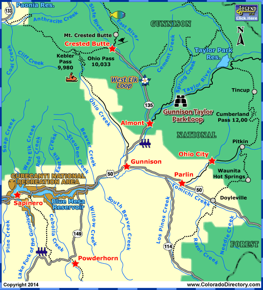
Not all towns appear on map. The publisher does not assume any responsibility for accuracy or completeness of maps. This information was compiled as accurately as possible.


Ute Indians originally inhabited the area of Gunnison. When Europeans started moving west to start farming and cattle ranching in 1874, the Ute tribe moved west to the Uncompahagre Valley. Five years later, miners struck rich gold and silver deposits, which brought the railroads to the area, and began a boom in the Gunnison area. The area was named for topographer Captain John W. Gunnison who was mapping a railroad route to the Pacific in 1853. But with the demonetization of silver in 1893, much the area became deserted. A few towns survived, and in the 1960s, the Crested Butte Ski Area brought the area back to life.

Gunnison Area

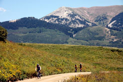
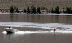
The Gunnison area consists of the towns of Crested Butte & Gunnison. In this area, there are many activities to keep you occupied. Hiking, mountain biking, and hunting are popular. Fishing is another exciting activity. The Lake Fork of the Gunnison & Taylor River are two of the most popular hot spots in Colorado. 750 miles of trout streams run through the area. Many other water activities are available near the many lakes and reservoirs as well.

Water Skiing in the Gunnison Area

For downhill skiers, Crested Butte Ski Area offers 1,600 skiable acres as well as the most double-black diamond areas in Colorado. With this to boast, Crested Butte is home to the US Extreme Skiing and Snowboard Championships. With an average of 229 inches of snow each year, this is a great place for other winter sports, including snowmobiling, cross country-skiing, and ice skating.

Curecanti National Recreation Area offers many recreational activities for those wanting to experience the outdoors.

For More Activities & Information:
Towns & Areas Crested Butte
Gunnison - includes Almont, Blue Mesa Lake, Ohio City, Parlin, Powderhorn & Sapinero

Fishing
Blue Mesa Reservoir Fishing Map
East River Fishing Map
Gunnison River Fishing Map
Lake Fork of the Gunnison River Fishing Map
Taylor River Fishing Map

Rafting
Whitwater Rafting Lake Fork of the Gunnison
Whitwater Rafting Taylor River

Scenic Byways/Drives
Gunnison Taylor Park Loop Scenic Drive Map

Snowmobile Trails
Black Canyon Snowmobile Trails
Cimarron Snowmobile Trails
Montrose Snowmobile Trails
Ridgway Snowmobile Trails

Aspen & Crystal River Valley Local Area Map / Buena Vista, Leadville & Park County Local Area Map / Colorado Springs Local Area Map / Denver Metro Local Area Map / Denver Mountain Local Area Map / Durango Local Area Map / Estes Park Local Area Map / Grand Lake Local Area Map / Greater Gunnison Local Area Map / Lake City Local Area Map

Montrose & Ouray Local Area Map / Pagosa Springs Local Area Map / Pikes Peak - Colo. Springs Local Area Map / Rocky Mountain National Park Local Area Map / Royal Gorge & Canon City Local Area Map / San Luis Valley Local Area Map / Steamboat Springs Local Area Map / Summit County Local Area Map / Vallecito Lake Local Area Map

colorado maps
calendars of events
national parks & monuments
scenic byways
fishing, fly fishing
hot springs, mineral springs, mineral bath
horse rides, horseback riding
atving
jeeping
rafting, kayaking, whitewater
attractions
golfing
meals served, fine dining, food, restaurant
museums, ghost towns, caves, mines, tours, sight-seeing
hunting, guides, outfitters
snowmobiling
downhill skiing
snowshoeing
cross-country skiing

Order your FREE Colorado Directory here! | Download our Colorado Map here

Colorado Towns & Areas | Places To Stay | Fun Things To Do | Colorado Maps
Links | Help | Contact Us | About Us

A-Z List of Accommodations | A-Z List of Fun Things to Do | Cabins & Cottages | Motels & Hotels | Mountain Lodges | Vacation Homes | Condos, Suites & Townhomes | Country Bed & Breakfast Inns | Tent Camping Sites in Campgrounds | RV Parks & Campgrounds | RV Sales, Services, Rentals & Manufacturers | Romance Packages | Family Activities | Dogs OK/Pets Welcome | By Water Accommodations | Swimming Pools | Guest Horses | Groups, Reunions, Meetings, Retreats & Conferences | Weddings & Elopements | Open in Winter | Calendars of Events | National Parks, Monuments & Historic Sites | Scenic Byways | Fishing | Hot Springs | Horse Rides | ATVing | Jeeping & 4WD | Rafting & Kayaking | Golfing & Golf Courses | Restaurants | More Fun Stuff | Hunting | Snowmobiling | Downhill Skiing | Snowshoeing | Cross-Country Skiing

Copyright by The Colorado Directory, Inc. This is a directory only; it is not and does not contain a recommendation,warranty, guaranty, inducement or endorsement of any kind. Representations herein were supplied by the individual businesses. The publisher, The Colorado Directory, Inc., does not assume any responsibility for truth, falsity or completeness of any representation made herein or any errors, changes, services rendered, or changes made in the use of this directory. This information was compiled as accurately as possible. Prices and services are frequently subject to change. Errors called to the publisher's attention will be corrected in the future. All rights reserved. No part of this publication may be reproduced, stored or transmitted in any form or by any means, without permission in writing from the publisher.